DOH: Mauna Loa eruption may affect air quality across the state


COURTESY USGS
Lava from Mauna Loa is seen moving downslope to the north from the cents on the northeast rift zone.

JAMM AQUINO / JAQUINO@STARADVERTISER.COM
Gov. David Ige and Gen. Kenneth Hara arrive for a news conference to speak about the eruption of Mauna Loa on Hawaii island.

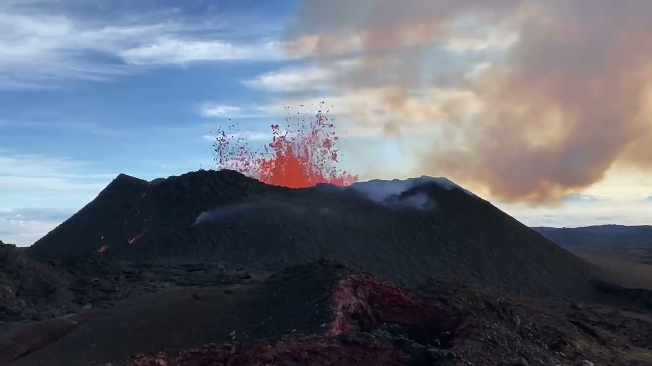
CHELSEA JENSEN/WEST HAWAII TODAY VIA ASSOCIATED PRESS
Lava pours out of the summit crater of Mauna Loa at about 6:35 a.m., today, as seen from Gilbert Kahele Recreation Area on Maunakea. Mauna Loa, the world’s largest active volcano, began spewing ash and debris from its summit, prompting civil defense officials to warn residents on Monday to prepare in case the eruption causes lava to flow toward communities.

COURTESY USGS
An eruption began late Sunday night in the summit caldera of Mauna Loa, the first since 1984 for the world’s largest volcano. Lava flows are mostly contained within the summit area and aren’t threatening nearby communities, USGS scientists reported.

COURTESY LACY MATSUMOTO
The view from Saddle Road on the Big Island early this morning shows the glow of the Mauna Loa summit eruption, which began late last night.

COURTESY USGS
An eruption began late Sunday night in the summit caldera of Mauna Loa, the first since 1984 for the world’s largest volcano. Lava flows are mostly contained within the summit area and aren’t threatening nearby communities, USGS scientists reported.

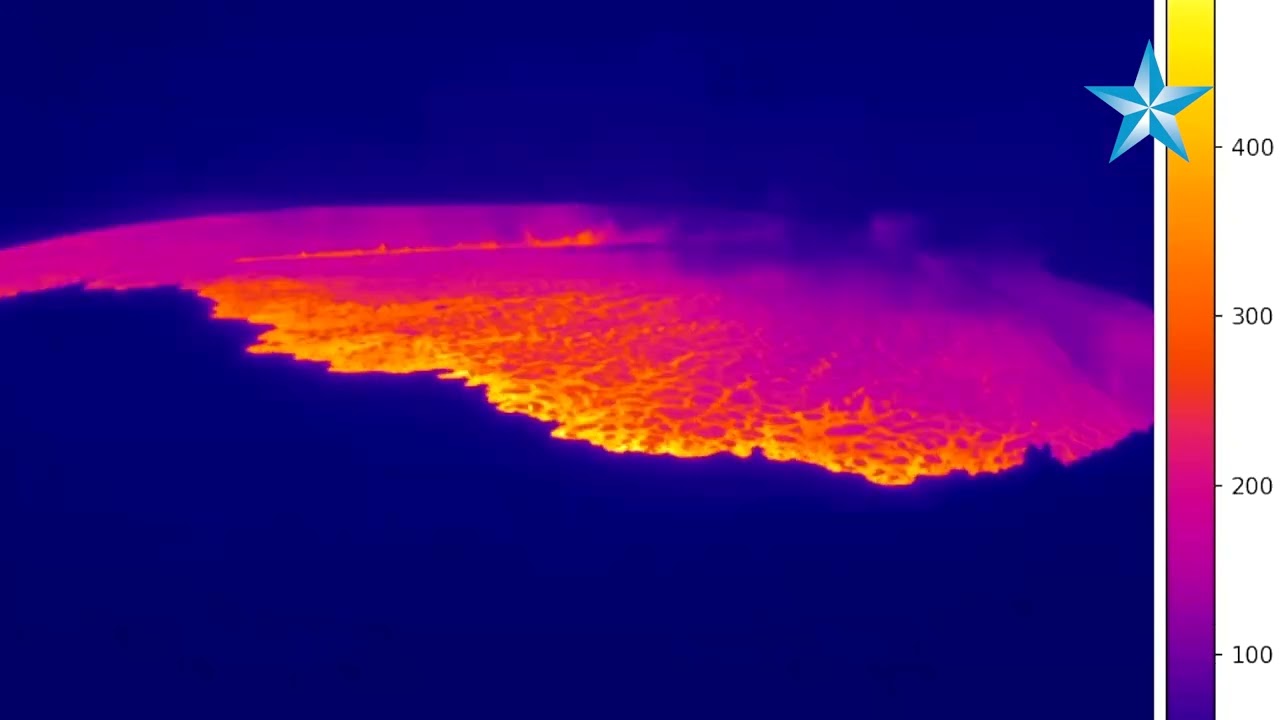
COURTESY USGS
This image is from a thermal camera on the north rim of Mauna Loa’s Moku’aweoweo summit caldera. The temperature scale is in degrees Celsius up to a maximum of 500 degrees (932 degrees Fahrenheit), according to USGS.

COURTESY USGS
Mauna Loa eruption as viewed from Waikoloa at about 1:25 a.m. today. The eruption is occurring from the volcano summit but lava has overflowed the caldera, USGS said.

ASSOCIATED PRESS
This map shows the lava flow hazard level zones for the Big Island.

COURTESY USGS
This U.S. Geological Survey map, posted Sunday, shows a swarm of earthquakes — the largest at magnitude 4.4 — that struck Mauna Loa volcano before and during its current eruption, which began late Sunday night.


UPDATE: 5:30 p.m.
The Mauna Loa eruption continues flowing along the northeast rift zone.
Hawaii County Civil Defense Agency reports that the lava does not pose a threat to any communities or infrastructure at this time.
There are three fissures of lava with only the lowest remaining active as of 1:30 p.m. Fissure No. 3 is above 10,000 feet and more than 10 miles away from Saddle Road, officials said.
Shelters will remain open tonight at Old Kona Airport in Kailua-Kona and Kau Gymnasium in Pahala.
5:08 p.m.
All Hawaii island public schools are scheduled to remain open on Tuesday, “and going forward unless otherwise noted,” according to the state Department of Education’s website.
The department plans to follow the advice of Civil Defense officials and monitor the conditions of Mauna Loa each day.
Families will be notified immediately if school operations are affected. Families are urged to update the child’s contact information on file at school, officials said.
A joint statement from the Hawaii island complex area superintendents also was released by the DOE. It reads:
“Based on the latest updates, we are cautiously optimistic but continue to monitor conditions closely and follow the guidance and direction from Hawaii County Civil Defense. As with all emergencies, the health and safety of our students and staff is our top priority. Our goal is to be able to keep schools open as long as we can do so safely, and avoid having to abruptly close school during the school day. We will be reviewing conditions on a daily basis, looking at a variety of factors such as air quality, transportation, and the direction of the lava flow. In the event that school operations are impacted, families will be notified and updated through official school channels.
“All Hawaii island schools are updating their contingency plans to account for this type of emergency, should a school need to transition to a different mode of instruction for an extended period of time. Transition plans will be communicated to school communities as needed.
Mahalo to our staff and school communities for their support and dedication.”
The statement was signed by complex area superintendents Stacey Bello, Kau-Keaau-Pahoa; Esther Kanehailua, Hilo-Waiakea; and Janette Snelling, Honokaa-Kealakehe-Kohala-Konawaena.
3:07 p.m.
Hawaii Department of Health officials are advising the public to be prepared for possible impacts on air quality as a result of the Mauna Loa eruption.
As of 2 p.m. today, the air quality remains normal across the state according to monitoring stations. The eruption may cause vog conditions, ash in the air and sulfur dioxide levels to fluctuate across the state, DOH’s news release said.
In the event of voggy conditions, officials recommend taking the following precautionary measures:
>> Reducing outdoor activities that cause heavy breathing such as exercising to minimize health risks and exposure. “This is especially important for sensitive groups such as children, the elderly, and individuals with pre-existing respiratory conditions including asthma, bronchitis, emphysema, and chronic lung and heart disease,” officials said in a news release.
>> Those with asthma or chronic respiratory disease should ensure prescribed medications are available and taken on schedule.
>> Those experiencing health effects should contact their medical provider as soon as possible if any symptoms develop or respiratory conditions worsen.
>> Stay indoors and close windows and doors. If using an air conditioner, set it to recirculate. If inside a car, turn on the air conditioner and set it to recirculate.
>> Face masks such as cloth, surgical, KF94, KN95, N95 do not provide protection from sulfur dioxide or vog. However, officials say they can be effective in outdoor environments in reducing the effects of falling ash and Pele’s hair.
>> Do not smoke. Avoid second-hand smoke if possible.
>> Drink plenty of fluids to avoid dehydration.
3 p.m.
Gov. David Ige offered his first public remarks on the eruption from his office this afternoon and reiterated that there are no present threats to people or property.
Ige also encouraged tourists who are planning to visit Hawaii not to change any plans they have for travel.
“Lava flows are not threatening any down-slope communities,” he said.
Ken Hon, scientist-in-charge of Hawaiian Volcano Observatory, said during a media briefing with Ige that the eruption appears similar to one from Mauna Loa in 1984, and that if current conditions continue without significant changes then lava could get near the outskirts of Hilo in about a week.
However, Hon and other state and county officials emphasized that Mauna Loa eruptions can be dynamic so the public should pay attention to advisories from the observatory, Hawaii County Civil Defense and other agencies involved.
The Hawaii Emergency Management Agency activated its emergency operations center this morning at about 1 a.m., and the Hawaii National Guard is on stand-by, according to Major General Ken Hara, adjutant general for the Hawaii National Guard.
Hon said the speed of the lava flow will take a couple of days to measure, but his estimate is that the leading edge of lava is likely moving at between 1 and 3 miles per hour as it moves further into uninhabited areas of the Mauna Loa summit region.
2:28 p.m.
The Mauna Loa eruption has not impacted any Hawaiian Airlines’ transpacific and interisland flights including service to and from Kona and Hilo, a spokesperson said.
“Our dispatchers are closely monitoring the eruption of Mauna Loa, and we are allowing guests to reschedule their travel without any change fees or fare differences,” said spokesman Alex Da Silva in a statement today.
The airlines have also added one extra flight today that will depart Hilo Airport at 6:15 p.m. and arrive at the Daniel K. Inouye International Airport in Honolulu at 7:05 p.m. to accommodate travelers whose plans may have changed.
The Mauna Loa eruption began in Mokuaweoweo, a summit caldera inside the Hawaii Volcanoes National Park, at about 11:30 p.m. Sunday, according to the Hawaii Volcano Observatory.
The eruption has since moved from the summit caldera to the northeast rift zone where fissures are feeding several lava flows. The fissures are at high elevations in an isolated remote area, said County Civil Defense Administrator Talmadge Magno.
Officials say the flows are not threatening any communities.
1:15 p.m.
Gov. David Ige held a press conference this afternoon to discuss the latest on the Mauna Loa eruption.
Speakers included Major General Kenneth Hara, Adjutant General for the State of Hawaii, Luke Meyers, Administrator, State of Hawaii Emergency Management Agency, Hawaii County Mayor Mitch Roth, Talmadge Magno, County of Hawaii Civil Defense Administrator and Ken Hon, Hawaii Volcano Observatory Scientist in Charge.
——
This livestream video has ended. Watch a replay at the top of the page.
12:25 p.m.
Hawaii island Mayor Mitch Roth said at noon today that Hawaiian Volcano Observatory scientists have indicated “to county officials that there is no imminent threat to the community at this time” from the Mauna Loa eruption in the northeast rift zone
The direction of the flow is good news for communities in the path of the southwest rift zone, such as Pahala, Oceanview and Captain Cook, which are considered at high-risk due to the area’s steep slopes.
“Our team is on full alert and is prepared to respond to whatever situation may arise as a result of the Mauna Loa eruption,” Roth said in a news release. “That said, we’ve been told that the lava is heading in the best possible direction, which is away from our communities. We’ll continue to monitor the situation and will be providing updates to the community regularly. Until then, we thank our state and county partners, departments, and agencies for their quick action and attention to every detail.”
Separately, County Civil Defense Administrator Talmadge Magno told the Honolulu Star-Advertiser that there are no major roadways in the path of the current lava flow.
County and HVO continue to caution that eruptions from Mauna Loa, the world’s largest volcano, can be unpredictable and long-lasting, and they recommend residents visit the county’s volcano hazards website for more information and updates.
Two shelters — at the Robert Herkes Gymnasium in Kau and the Old Airport Gymnasium in Kailua-Kona — have been opened as a precaution. But no evacuations have been ordered and all public schools are opened. Mauna Loa Access Road is the only road to be closed so far.
It is “unclear” how long the eruption will last or what the volume of lava output will be, county officials said.
Hawaii Emergency Management Agency officials said in a tweet, “There have been some reports of vog — irritating volcanic fog — in the Saddle area.”
9 a.m.
The ashfall advisory for Hawaii island and its surrounding waters has been canceled.
The National Weather Service advises people to remain mindful of the potential for low air quality due to vog.
8:30 a.m.
All five Southwest Airlines flights today from Daniel K. Inouye International Airport in Honolulu to Hilo International Airport have been canceled.
7:45 a.m.
Hawaiian Volcano Observatory officials say that the eruption of Mauna Loa has moved from the summit caldera to the northeast rift zone.
“The eruption of Mauna Loa has migrated from the summit to the Northeast Rift Zone where fissures are feeding several lava flows,” said the latest update from the U.S. Geological Survey scientists.
“HVO staff on an overflight at approximately 6:30 a.m. HST confirmed fissures at high elevations within Hawaii Volcanoes National Park are feeding lava flows upslope of the Mauna Loa Weather Observatory. Lava flows are not threatening any downslope communities and all indications are that the eruption will remain in the Northeast Rift Zone. Volcanic gas and possibly fine ash and Pele’s Hair may be carried downwind,” the update said.
The Hawaii Emergency Management Agency said “the shift of the erupting area into the northeast rift zone takes the hazard into much less steep terrain. That would provide more time for preparation and early warning, and take the threat away from the steepest slopes of the volcano where lava moves the fastest.”
HI-EMA tweeted, “Latest volcano update from @USGSVolcanoes indicates several lava flows were seen from the air north of Mauna Loa’s northeast rift zone, including flows upslope from the Mauna Loa Weather Observatory. No downslope communities are currently threatened.”
However, HVO officials said residents at risk from Mauna Loa lava flows should review preparedness and refer to Hawaii County Civil Defense information for further guidance.
“Based on past events, the early stages of a Mauna Loa rift zone eruption can be very dynamic, and the location and advance of lava flows can change rapidly,” the HVO update said. “HVO is in close consultation with emergency management partners and will monitor the volcano closely to provide further updates on activity.
7:10 a.m.
Hawaiian Volcano Observatory confirms that lava has exited Mauna Loa summit and can be seen on the northeast flank, county officials said.
Hawaii County Civil Defense said the northeast flank is not populated and the overflow of lava from the summit “does not pose a threat to any communities at this time.”
The National Weather Service, meanwhile, has issued an ashfall advisory for all districts of Hawaii Island through today with trace amounts of ash and vog expected.
People with respiratory illness should remain indoors, county officials said, adding “if you must go outdoors, use face coverings to prevent inhaling ash particles.”
Shelters are open at Old Kona Airport in Kailua-Kona and Kau Gymnasium in Pahala, but no evacuations have been ordered and there is no immediate threat to residents.
5:30 a.m.
Hawaii island Mayor Mitch Roth reassured Big Island residents that “this is not a time to be alarmed,” but urged them to stay informed and be prepared after Mauna Loa’s summit eruption that began late last night.
At a joint, early-morning news conference via Zoom, Roth said he has issued an emergency proclamation as a precaution, but no evacuations have been ordered and no communities on the slopes of the world’s largest volcano are threatened.
Ken Hon, scientist-in-charge of Hawaiian Volcano Observatory, said officials are trying to figure out if this eruption will be contained to Mauna Loa’s Moku’aweoweo summit caldera, or will include one of the volcano’s rift zones. However, there has been lava overflow sighted from the southwest and northeast sides of the summit.
He said past eruptions contained to the summit have “not gotten anywhere close to surrounding communities,” but it “may be a while” before scientists know if the eruption will include a rift zone, which could become a threat.
Hon cautioned that a Mauna Loa eruption is always something to be concerned about. If the eruption moves to a rift zone, lava could move quickly down the slopes of the mountain, he said.
USGS officials said the lava has been mostly contained to the summit area but some overflow has been observed.
Hawaii County Civil Defense administrator Talmadge Magno warned that ash and vog from the eruption could be blown by southerly winds. Residents with respiratory problems should be aware of the threat and stay indoors if needed, officials said.
Magno and Roth said the Hawaii island resort areas are not threatened by the eruption and are safe at this time.
They said the island’s officials have been preparing for an eruption and alerting residents since seismic activity on the mountain began increasing in September.
Roth said Gov. David Ige and Gov.-elect Josh Green have been alerted and that both offered their support.
Roth urged residents to visit the county’s volcano hazards website for more information and update.
The state Department of Education, meanwhile, said as of this morning, all public schools on the Big Island remain open today.
“The department continues to monitor the potential impacts of the Mauna Loa eruption. Civil Defense and Hawaii County officials have advised that no school closures are needed at this time; mandatory evacuations have not been ordered and school operations can safely continue at this time,” DOE officials said in a news release.
They said families will be updated through official school channels if conditions change.
PREVIOUS COVERAGE
Mauna Loa volcano on the Big Island is erupting with lava flows at the summit region visible from Kona, the U.S. Geological Survey reported early this morning.
The eruption began late Sunday night in the summit caldera of the world’s largest volcano and lava flows are contained within the summit area and aren’t threatening nearby communities, USGS scientists reported.
“However, lava flows in the summit region are visible from Kona. There is currently no indication of any migration of the eruption into a rift zone,” the Hawaiian Volcano Observatory said in a statement.
Hawaiian County Civil Defense has been activated and has opened shelters at the Robert Herkes Gymnasium in Pahala and at the Old Airport Gymnasium (Kailua Park) in Kailua-Kona amid reports of self-evacuations along the South Kona coast.
“Multiple images have surfaced on social media indicating lava activity outside of the caldera. At this time, no lava migration into a rift zone has been confirmed,” according to a statement from the office of Big Island Mayor Mitch Roth.
Hawaiian Volcano Observatory has increased the alert level for volcanic activity on Mauna Loa from “advisory” to “warning,’ and increased the aviation threat level from “yellow” to “red” to reflect the presence of airborne gases, ash particles and possibly “Pele’s hair” volcanic glass fibers.
The Hawaii Police Department has closed Mauna Loa Access Road at the intersection with Daniel K. Inouye Highway.
The eruption, the first since 1984, comes after weeks of increased seismic activity on Mauna Loa with scores of small tremors each day.
The latest eruption was preceded by a series of earthquakes last night, including a magnitude 4.4 tremor.
The USGS warned residents at risk from Mauna Loa lava flows should review their eruption preparations. Scientists had been on alert because of a recent spike in earthquakes at the summit of the volcano, which last erupted in 1984.
The National Weather Service in Honolulu issued an ashfall advisory for portions of the Big Island, saying up to a quarter-inch of ash could accumulate in some areas.
Mauna Loa is one of five volcanoes that together make up the Big Island.
Rising 13,679 feet above sea level, Mauna Loa is the much larger neighbor to Kilauea volcano, which erupted in Leilani Estates and destroyed about 700 homes in 2018. Some of its slopes are much steeper than Kilauea’s so when it erupts, its lava can flow much faster.
During a 1950 eruption, the mountain’s lava traveled 15 miles to the ocean in less than three hours.
The Hawaii Emergency Management Agency said this morning that about half of all recorded Mauna Loa eruptions have been confined to the summit area.
HI-EMA said people living on the Mauna Loa slopes should stay informed through HCCDA alerts and take steps to prepare in the event action is needed. For more information visit: https://hawaii-county-volcano-hazards-hawaiicountygis.hub.arcgis.com.
This breaking news report will be updated as more information becomes available. The Associated Press contributed to this report.


