Mauna Loa eruption continues, creating spectacle from afar


TOM KUALII / THEEDGEEXPLORER.COM / SPECIAL TO THE STAR-ADVERTISER
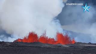
Fountaining lava flowed Tuesday morning on Mauna Loa’s northeast rift zone on Hawaii island.

©2022 MAXAR TECHNOLOGIES / ASSOCIATED PRESS
Waves of orange, glowing lava and ash blasted and billowed from the world’s largest active volcano Monday in its first eruption in 38 years. In this satellite image, lava flows from Mauna Loa.

ASSOCIATED PRESS
Hawaii County Mayor Mitch Roth issued an emergency order prohibiting parking from mile marker 16 to mile marker 31 on Daniel K. Inouye Highway, also known as Saddle Road. Spectators pulled over Tuesday on Saddle Road near Hilo to watch Mauna Loa’s eruption.

TIM WRIGHT / SPECIAL TO THE STAR-ADVERTISER
Mauna Loa’s eruption turned the night sky above Hilo a reddish orange Monday night.
Mauna Loa’s first eruption in nearly 40 years marked its second day Tuesday with lava continuing to march across the mountain’s remote northeast rift zone toward Hawaii island’s saddle region.
So far, the event has offered spectacular nighttime viewing and distant picture-taking but little in the way of destruction.
Even the air quality at state Department of Health monitoring stations has been good despite estimated emissions of 250,000 tons a day. The visible plume has been blowing off to the north, officials said.
While the eruption’s longest and largest lava flow, from Fissure 3, has traversed some of the island’s most remote landscape, it did cut across the road that serves the Mauna Loa Observatory, the National Oceanic and Atmospheric Administration facility that sits above the 11,000-foot level.
The laboratory is best known as the site where carbon dioxide has been measured in the atmosphere for more than 60 years, creating the Keeling Curve baseline that has had a huge contribution to the science of climate change.
A spokesman for NOAA on Tuesday said the lab’s staff of eight is safe but that the facility will remain closed for the time being, along with a pause in measurements.
As of 3:30 p.m. Tuesday, the flow from Fissure 3 was traveling at a rate of about 1 mph and had reached some 4.5 miles from Saddle Road, according to the Hawaiian Volcano Observatory. In the afternoon, fountains at the fissure were shooting up to between 131 and 164 feet, while the fountains at Fissure 4 were reaching 16 to 33 feet.
There was no active lava within Mokuaweoweo caldera — where the eruption started — and there was no lava erupting in the southwest rift zone on the other side of the mountain. Officials continued to say they didn’t expect any eruptive activity outside the northeast side of Mauna Loa.
While Hilo still remains vulnerable, the flow has a long way to go, and it is approaching an area of more level terrain that should help to slow it down — much like what happened during the Mauna Loa eruption in 1984, when lava failed to reach the Big Island’s most populous city.
“At about 4 miles from Saddle Road, it’s going to hit some flatter ground and presumably slow down considerably, and the mode of movement may change as well,” said Ken Hon, Hawaiian Volcano Observatory scientist-in-charge. At higher elevations the flow was being channelized, he said.
Earlier in the day, Hawaii County Mayor Mitch Roth said he issued an emergency order prohibiting parking from mile marker 16 to mile marker 31 on Daniel K. Inouye Highway, also known as Saddle Road. Roth issued the rule after numerous people parked their vehicles along the highway to take photos and videos of the lava flow, creating unsafe conditions.
“It’s a highway where cars go 60 miles an hour. It’s not a safe place to park,” Roth told the Honolulu Star-Advertiser. Vehicles will be allowed to park at the Gil Kahele Recreation Area, which will remain open 24 hours a day with security guards, according to the proclamation.
Meanwhile, shelters that opened Monday at Old Kona Airport in Kailua-Kona and Kau Gymnasium in Pahala closed at noon Tuesday.
Elsewhere, Gov. David Ige signed a proclamation Monday night declaring a disaster emergency relief period. The declaration, among other things, allows authorities to limit access for emergency responders as the eruption continues.
On Tuesday the state Department of Land and Natural Resources closed another Mauna Loa recreation area: Unit J of the Kapapala Game Management Area.
“No one should be accessing Mauna Loa at this time. Our sole focus is on public safety, which depends on where lava ultimately flows,” Steve Bergfeld, the state Division of Forestry and Wildlife’s Hawaii island branch manager, said in a statement.
On Monday, officials announced the closure of the 50,000-acre Mauna Loa Forest Reserve, the Kipuka ‘Ainahou Nene Sanctuary, ‘Ainapo Trail and cabin, and the Kapapala Forest Reserve. All areas will be closed for 90 days.
Earlier, the National Park Service closed access to the Mauna Loa summit from the south, and Monday morning, officers from the state Division of Conservation and Resources Enforcement and the Hawaii Police Department established a roadblock at the intersection of Mauna Loa Observatory Access and Saddle roads. It is being manned 24 hours a day.
Meanwhile, the Hawaii Tourism Authority is urging tourists — and potential tourists — to forge ahead with their travel plans to the islands.
While the Big Island’s two major airports — Ellison Onizuka Kona International Airport at Keahole and Hilo International Airport — are operating normally, it is recommended that travelers check with airlines on the status of flights.
Despite the good air quality Tuesday, state health officials were warning the public to be prepared for air quality impacts from the eruption.
“Conditions have the potential to change rapidly, and people need to be ready to take steps to protect themselves, because there may not be a lot of time to prepare or plan once conditions change,” state Toxicologist Dr. Diana Felton said.
She said COVID-19 face masks like KN95s do not provide protection from sulfur dioxide or vog. However, they can help reduce inhaled hazardous particulates such as falling ash and Pele’s hair when walking outside.


